File added to favourites.
nie.dodano.jednostki.do.ulubionych
Added to collection
Zestawienia powierzchni odcinków przypadających z Polski do Niemiec i z Niemiec do Polski w związku z regulacją rzeki Drwęcy stanowiącej granicę państwową w pow. lubawskim Expand Collapse
Reporting remarks
is available to logged in users.
Option available after logging in Log in or if you do not have an account yet Create an account
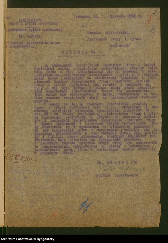
Type of file Land survey and cartographic documentation Translated title No data Reference code 6/4/0/7.4.1/25371 Date / Period of creation brak daty Dates 1920 - 1939 Content No data Folder reference No data Physical condition Good Microfilming status No microfilm Languages: polski Old reference code 2753, 21950 Shared jednostka.cywilna.dostepnosc.12 Comments No data Printing house No data Execution technique No data Publisher / publishing house No data The colouring of the map No data Map type by scale No data Map type by intended use No data Map emblem No data Status of map manuscript copy Sections 10 Height No data Frame No Number of sheets 10 Total (sheets + doublets) 10 Original scale No data Material No data Map type by manner of use contact print Map type by content No data Map type by rendition No data Map is part of No data Width No data Number of doublets 0 Number scale No data Coordinate system No data The form of the file Postać tradycyjna Substantiation No data Sharing restrictions expire on No data Microfilm number No data Authors: Name and surname / Role Owners: Name Surname / Reference code No data The sections of the map: number No data Map sections: name No data Map sections: number of sheets No data Map sections: emblem No data Map sections: dates No data The sections of the map: the number of doublets No data
przekroczono.liczbe.dozwolonych.znakow
slowo.znajduje.sie.na.czarnej.liscie
nie.mozna.dodac.tego.samego.tagu.ponownie
Tags users tags indexes given by archives
Add another tag
![image.from.unit "[Rozporządzenia Wojewody Pomorskiego dotyczące bezpieczeństwa publicznego]"](https://photos.szukajwarchiwach.gov.pl/c19588a353546e9745723430780977916b71848b8acdd1e12f022000126307c8_mid)
![image.from.unit "[Objęcie przez dr Stefana Łaszewskiego urzędu wojewody pomorskiego - gratulacje, telegramy]"](https://photos.szukajwarchiwach.gov.pl/f5d70f5ace6a018e82e0fd4867f19ca0af99cb4acfef659ada356bf715bf0877_mid)
![image.from.unit "Akta przyjazdu pana Naczelnika Państwa [na Pomorze]"](https://photos.szukajwarchiwach.gov.pl/4b5828d699623754e41a41cec57a8daf629fc3d19e80f751670529efd754bab7_mid)